
Long hauls have always been fun for me. As you pass by every town, or take a leak or grab some snacks during stopovers, road travels give you a glimpse of a community's way of life, a wee bit of their culture, tidbits of local information, and most of all enjoy the beautiful scenery you will always remember in your life.
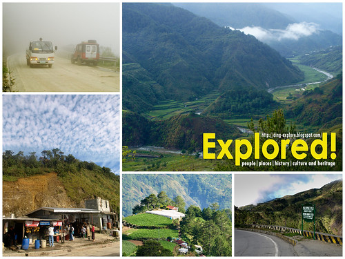
When photography invaded my bloodstream, I learned to spot places that interest me. Such is the case for Halsema Highway. Whether you are traversing the Banaue-Bontoc-Baguio route or vice versa, you will not miss Halsema Highway. It is the only road that connects the three. Sans the road cuts and landslides after the typhoon Pepeng, I must say, this is one of the most scenic routes I have traveled so far in the Philippines.
The other three, which I consider beautiful are:
- Cagayan de Oro-Bukidnon-Davao route which boasts of its Ver Overview ;
- Lebak-Sen. Ninoy Aquino (SNA)-Isulan route in Sultan Kudarat where you will pass by a private rainforest in a former logging area owned by the Consunjis and get a good view of the canyons and feel like you were in a "Wild, Wild, West" movie once you reach SNA, and the
- Osmeña Highway from Dipolog City to Pagadian City, where you will cross a river via an overflow bridge that transports you to a similar scene in the movie "A River Runs Through It" as well as feeling the high while traversing a highway literally on the mountaintop.
So what is it about Halsema Highway that makes is oh-so-fascinating and important?
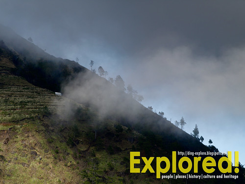
First, it is scenic. I guess no one will argue with me on that. Anybody who has passed through this highway will always open their car windows to feel the cold breeze on their cheeks. The winding roads will not lull you to sleep, but rather be more attentive to every bend for you will not know what it has to offer--

- the view of the Sto. Niño Mines not far from La Trinidad;
- a glimpse of the Ambuclao Dam on a clear sunny day;
- clouds rolling over the mountain ranges in a beautiful and freezing morning;
- a glimpse of Mt. Pulag on your right;
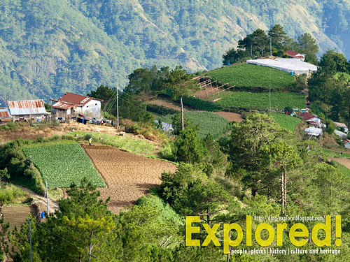
- the vegetable terraces in Natubleng, Buguias, Benguet--home to the sweetest carrot in the Philippines,
- the mountain sides teeming with moss, ferns, and wild sunflowers lining up the roadsides from October to February,
- the wild lilies freely growing along the streams and along the road,
- the interesting faces of old men and women munching on their momma (betel nut) while basking under the sun
- veggies on sale along the road,
- the fog you have always been wanting to see, feel, smell and even taste;
- the children's rosy cheeks,
- and not to forget the smell of chicken dung in Tublay, Benguet, and much much more!
Second, it is a historical and an engineering feat. Formerly known as Mountain Trail, it was renamed to Halsema Highway, after its builder, Eusebius Julius Halsema. It originally traverses from La Trinidad, Benguet to the town of Bontoc in Mountain Province. Now it is extended to include the Bontoc-Banaue Road.
So what would be the interesting stops you should not miss?
Guerilla Saddle
 |
| Guerilla Saddle, Km. 26, Caliking, Atok, Benguet |
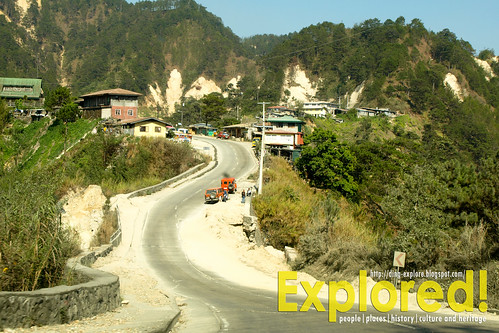
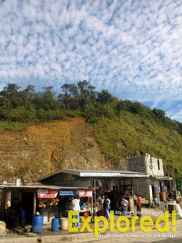
If you happen to go on a road trip with your own vehicle, you can always stop here. Located in Km. 26 in Caliking, Atok, Benguet, Saddle has been the usual stop-over for buses back in the day. I also blogged about it in my Mono-logues. I remember that we had lunch here back then. So that means the entire morning was spent on traveling to this place.
Now it is just around 1.5-hour drive from Baguio City. With better roads, this has just become a stopover for cargo trucks. Seldom you see buses stopping here for a long time except for a wee break and to pick up some passengers. But it is always nice to stop here to try the food that they serve and have a glimpse of the Cordillera culture.
Historically, this is the place where the guerillas of the WW II fought side by side with the soldiers of the 66th Infantry USAFFE against the retreating Japanese soldiers.
The Philippine Pali or the Highest Point of the Philippine Highway System
The first time I passed through this point was in 1991, when Halsema Highway was still a dirt and rocky road and only the marker and cogon grass were visible in the area, very much similar to this one. I had no camera with me then that is why I promised myself that I should have a picture when I have the chance to travel through Halsema Highway again.
In 2007, I had the chance to do a study on weaving in the Cordillera, and I got the rare chance to visit this point--at daybreak. Though we left Baguio City at exactly 4 am when it was freezing cold, to attend a workshop in Mount Data Hotel in Mountain Province, we were rewarded with this beautiful sunrise.
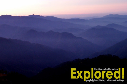 |
| Sunrise at Philippine Pali at 5:34 AM |
Back in 1991, there was just cogon grass behind the marker. Now, it looks different and very much unpleasing to the eyes. Save for the view deck that allows you to take more scenic photos. The road then was really bad, but I liked it better than when the place had a more rustic feel, and reaching the point back then would seem like a conquest for every Filipino traveler. Nonetheless, progress has taken its steps in this part of the Philippines, so it is a breeze passing through it.
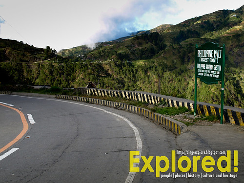 |
| The new marker which says "Philippine Pali" |
The Philippine Pali or the Highest Point of the Philippine Highway System is located at Cattubo, Buguias, Benguet. It has an elevation of 7,400 ft above sea level. The new name "Philippine Pali" was coined because of its resemblance with Hawaii Pali. (It does not look like similar to me, but perhaps the similarity is the vastness of the mountain ranges.).
From the view deck, one can be refreshed by the cool climate and the visual treat that the place has to offer. One can see the mountain ranges of Atok, Tublay, Bokod, and Kabayan, including the majestic Mt. Pulag. It is located at Km.53 along the Halsema highway, which is about a 2-hour drive from La Trinidad, the capital town of the province. After my second visit to this place, I was able to pass through here several times more. Here are some of the photos I took.
 |
| The mountain range at the left side. |
 |
| Zooming into the vegetable gardens on top of the hill in the middle. |
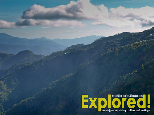 |
| The mountain ranges towards the right. |
Sabangan Stop
I have not gone this far from Baguio City. Actually, it was my first time to reach this place. I have only been up to Mount Data. It just so happens that when we went to Bontoc for the Lang-ay festival, there was an ongoing road construction in the Cagayan Valley Road along the stretch of Nueva Vizcaya. So the Cable bus took another route and passed through Baguio City instead.
I have been wanting to take a leak but then the bus never stopped. We were finally relieved that we reached this stop. I was suddenly roused from sleep. It was cold. I didn't know the place. So I immediately went to the restroom to relieve myself. When I came out, I was surprised with some tourists taking pictures of the place on the view deck. I thought it was just any other stop along the way. So I immediately went back to the bus and grabbed my camera.
It was freezing cold and I could not focus. My hands were shaking. It was still a bit dark though the sun was already peaking on the mountain tops. I did not have prime lenses to shoot under low light conditions. So I propped my arms on the railings and started shooting. I only had four frames, when the conductor was already calling us to return to our seats in the bus which was about to roll in a jiffy. I did not even have the luxury of time to know what this place was, nor even look for signage.
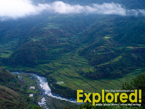
So, I tried to google it to find out what this stop is and I stumbled on Ferdz Decena's similar blog entry. So, it is called Benenas Park/ Panoramic Parkview. And this is what I've got as a remembrance. I had at least one good photo of the Centipede Rice Terraces.
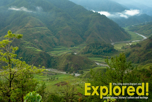 |
| Centipede Rice Terraces taken at 5:37 AM. Thanks to Lightroom for improving this shot! |
 |
| Panning to the left and this is what I got, taken at 5:39 AM. |
Mount Polis

This has become a traditional bus or jeepney stop from Bontoc to Banaue or vice versa. If you come from Manila via the Cable Bus, then there is always a chance to stop here. It is usually where the drivers have their quick breakfast of bread and steaming freshly brewed coffee.
Well, the coffee is a bit bland. You should not ask for more, especially when you arrive a little before 6 AM when thick fog engulfs the entire place and all you wanted to have is a cup of coffee to beat the chilly morning. Anyway, it would cost you only P10 pesos.
Mount Polis is one of the Luzon's highest peak along with Mount Pulag, Mount Puguis, and Mount Data. It is home to a tropical mossy rainforest and a destination for birding activities. To those who are interested in biodiversity, this is the place to go. Being a tropical rainforest, it usually is foggy and always raining on this part of the Cordillera.
Pardon me, but I do not exactly know what barangay is this place. In fact, it is a contested area. two provinces, namely Mountain Province and Ifugao are claiming this area. Aggravating the problem is also the claims of Hungduan and Banaue, both municipalities of Ifugao. which prompted Ifugao Governor Teddy Baguilat to set up police outpost to guard the area.
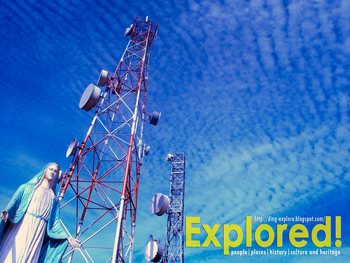 |
| Mt. Polis landmarks--The large statue of the Blessed Virgin Mary and cellular towers. |
Anyway, you can always remember this place with a cellular site tower and a large statue of the Blessed Virgin Mary. There is nothing spectacular about the place. It is a usual thriving community abuzz with some economic activities. What makes this interesting is the ever-changing weather conditions and the people living in it.
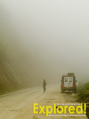 |
| Mt. Polis on a foggy morning. |
On a cold, rainy day, you will be treated to a thick fog which makes you feel you are in the clouds. The cold weather adds to the romantic ambiance while you are sipping that cheap-bland-upland-freshly brewed coffee Arabica.
The people are just so nice and very hospitable, but they, especially the women and children, are shy in front of the camera. People from the Mountain Province and Ifugao are naturally shy, and should I say they wary about strangers photographing them. So better be careful. I had a bad experience with the old people of Sagada and Bontoc while I was photographing them. Save for my 70-300 mm that I have become unobtrusive and I was able to attend the Lang-ay festival that allowed me to take all photos of people I want--in their full glorious and majestic native and authentic costumes!
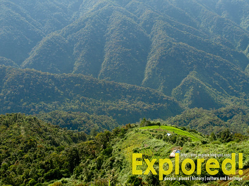 | |
| Vegetable gardens below. |
 On a clear day, you will be treated to beautiful cloud formations and a good view of the mountain ranges across the road.
If you missed buying some veggies in Sagada or Bontoc, you can buy from here, too! Very fresh--straight from the farm right below--and very, very cheap!
So on your next road trip, don't miss these stops.
See more photos in FLICKR.
Do you like this article? Like us on Facebook, too!
18 comments :
Gorgeous photos! I love the sunrise shot at Philippine Pali. What an interesting concept to focus on the stopovers along a highway. :)
Thanks, kara!
I love the shot of the foggy morning. It adds thrill to the journey not knowing what lies ahead. (Oh wait, this could be fatal on a mountain road no less!)
I love it, too, LDP (Claire)! Oo nga. delikado. Hehe...thanks for dropping by.
Beautiful photos! I am a new Follower from Jamaica.
Judy - JUDY H-J'S THOUGHTS
Thanks, Judy!
yay, I love the foggy part Ding, I look at it so superb!
Salamat Edmar!
great photos! galing :) one thing i learned from your post is to always keep my eye open when travelling. i've been here several times, but i never really took the time to see helsema highway... hanggang guerilla saddle lang and then tulog na ulit. hehe :)
this is just right for my Mt. Pulag climb next month... i think it will pass by Halsema High way... thanks for sharing Ding!
Gladys, nakakatulog din ako, but I try to wake myself up pag stop overs na. Hehe.
Mervs, Yeah, you will pass through it. Just take note about the places. I am not sure about Sayangan stop and Mt. Polis, but you will pass through Saddle and Phil. Pali for sure.
I've been to the north several times, and I do remember taking the Halsema Highway. Unfortunately, I'm "masa"--masandal, tulog, so it's really too bad I haven't been able to appreciate it as much as you have. :) Love your pics!
Next time Aleah, idilat ang mga mata...hehe. Thanks!
how is the state of halsema highway recently
will be driving sometime June 2012
thanks!
HI Anonymous, I have no information now. There were some portions of the road that were affected by the landslides since 2010. But they are working on the repairs now. I just hope its oka nowadays. Haven't been there lately. Best to ask is DPWH-CAR when you reach Baguio.
I swear I love the photos. Photos can really paint a thousand words. Love it..
Thanks, Juanderful Pinoy!
Thanks for featuring our beautiful place. I have seen the transformation of the Halsema Road as I pass through it at least once a month when used to live in Natubleng. Later on we settled in La Trinidad, the town next to Baguio. Today, I still go back to Halsema just to drive and take photographs. I just want to point out that Mt. Polis is no longer part of Halsema Road, it was only the Baguio to Bontoc Road. Halsema was the mayor of Baguio from 1921 to 1933 and he was the one who insisted on the creation or the improvement of the Mountain Trail that used to be a horse trail used by miners in Lepanto and vegetable farmers in the area. The construction was a long process until its recent improvement but it took 11 years until a car can finally pass from Baguio to Bontoc.
Post a Comment